Chesapeake Climate Data Hackathon a Success
EXPERIENCED CODERS AND OLD DOMINION UNIVERSITY STUDENTS DEVELOP NEW TOOLS TO SOLVE PROBLEMS WITH FLOODING IN HAMPTON ROADS AREA
Chesapeake Conservancy, Intel, Old Dominion University, & Esri Hosted Weekend “Code for Good” Event to Support President Obama’s Climate Data Initiative
VIRGINIA BEACH, VA – Chesapeake Conservancy, based in Annapolis, MD, today announced that the Chesapeake Climate Data Hackathon, which took place November 8-9, 2014, was a great success with significant progress made on new tools that will be used to help government officials better understand and track flooding problems caused by climate change and sea level rise in the Hampton Roads region. The tools will also give the public the information they need to understand when and where flooding will affect their daily lives.

“The Chesapeake Conservancy is thrilled with the results of our Chesapeake Climate Data Hackathon and we’re proud to have partnered with Intel in support of the White House Climate Data Initiative,” Joel Dunn, executive director of the Chesapeake Conservancy, said. “All of these bright minds, students and professionals alike, tirelessly spent the weekend hard at work. Their creative thinking has led to some real and tangible solutions that will help Hampton Roads be more resilient to climate change. This is a showcase example of a public, private, non-profit, and academic collaboration that worked.”
“Intel is very pleased to have been a part of the Chesapeake Hackathon. We know that the information needed to help reduce the impacts of flooding and other environmental disasters exists, it’s just a matter of capturing and applying it in the best ways possible,” Stephen Harper, Global Director, Environment and Energy Policy, Intel Corporation, said. “The Hackathon led to some truly innovative solutions for government officials and residents of the Hampton Roads area to better manage future floods.”
“Not only was the Hackathon a success, it was a really fun time. It is our hope that these new tools and the Hackathon model itself, can be replicated by other jurisdictions. We look forward to sharing information and technology to put this model to use elsewhere,” Jeff Allenby, director of conservation innovation for the Chesapeake Conservancy, said.
Some of the highlights that came out of the Hackathon include making significant progress on two core projects:
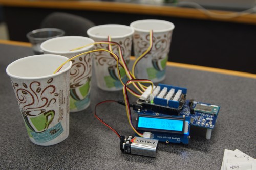
- Conceptually designing and doing preliminary testing for a low cost sensor package (under $100) that would measure a) water height, b) conductivity (important to know if its salt (bay) water or fresh (rain) water that is causing the flooding), and c) soil moisture (to tell how bad rain flooding will be; drier soil will not flood as much as saturated soil). This sensor package will run off an Intel Edison board and be able to wirelessly transmit the real-time data back to a central point, most likely the Department of Public Works or Emergency Management, where it can be displayed on public facing web-maps and help direct operations before, during, and after a flood event.
- Working to improve the ease of use of the City of Norfolk’s Tidal Inundation Tracking Application for Norfolk (TITAN) web-mapping application to include a time-enabled slider that combines data from NOAA tide gauges and National Weather Service information to determine the anticipated tide/flood level at any time in the next 3 days and map which areas in the city of Norfolk are expected to be flooded based on that tide level (currently visitors to the site have to look the data up in a table and load the appropriate tide level manually). This system will update itself every half hour as the source data is updated. In the future, this map could also include data from the sensor packages in real time.

Intel’s Code for Good program aims to tackle society’s most pressing problems by connecting nonprofit organizations with volunteer software developers, web site creators, and student programmers.