Fish & Wildlife Conservation Tools
The Chesapeake Conservancy is working with organizations throughout the Chesapeake Bay watershed to map environmental, ecological, and biological data that can inform natural resource management. Our partnerships are multi-scaled and involve areas as small as a local watershed and areas as large at the northeast United States.
In partnership with faculty at Susquehanna University, the Chesapeake Conservancy is mapping data collected as part of the PA Fish & Boat Commission’s Unassessed Waters Initiative. Susquehanna University has collected data at over 600 different sites since 2011, including information about water temperature, pH, conductivity, alkalinity, and trout characteristics.
See below to explore data from the Unassessed Waters Initiative.
Since 2013, the Chesapeake Conservancy also has helped to develop “Regional Conservation Opportunity Areas” (RCOA) for the northeast region (from Maine to Virginia) with partners from 13 states, the North Atlantic Landscape Conservation Cooperative (LCC), the U.S. Fish and Wildlife Service, nongovernmental organizations, and universities. The project has resulted in a suite of resources that partners can use voluntarily as a complement to their own information to help identify the best opportunities for conserving and restoring terrestrial, aquatic, and coastal ecosystems and the host of different species that depend on them.
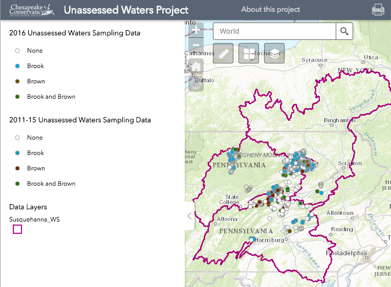
Explore data from the Susquehanna River Freshwater Research Initiative
The Chesapeake Conservancy, in partnership with Dr. Jonathan Niles at Susquehanna University’s Freshwater Research Initiative, is mapping water chemistry and biological data collected as part of the PA Fish & Boat Commission’s Unassessed Waters Initiative.